


CartoDruid - GIS offline tool
CartoDruid - GIS offline tool का विवरण
कार्टोड्र्यूड एक जीआईएस एप्लिकेशन है जिसे इंस्टीट्यूटो टेक्नोलोजिको एग्रारियो डी कैस्टिला वाई लियोन (आईटीएसीएल) द्वारा विकसित किया गया है, जिसे फील्डवर्क का समर्थन करने के लिए एक उपकरण के रूप में डिज़ाइन किया गया है। यह भू-संदर्भित जानकारी के ऑफ़लाइन संपादन की चुनौती का समाधान करता है।
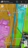
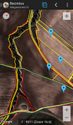
अपर्याप्त मोबाइल कवरेज वाले कई फ़ील्ड क्षेत्रों में, कार्टोड्र्यूड डिवाइस पर संग्रहीत रैस्टर और वेक्टरियल परतों के विज़ुअलाइज़ेशन को सक्षम करके एक विश्वसनीय समाधान प्रदान करता है। यह नई ज्यामिति (इकाइयों) को सीधे स्क्रीन पर चित्रित करके या एम्बेडेड या बाहरी जीपीएस का उपयोग करके बनाने की अनुमति देता है।
कार्टोड्र्यूड उपयोगकर्ता के अनुकूल है और इसके लिए पिछले जीआईएस ज्ञान की आवश्यकता नहीं है, जिससे फील्डवर्क जानकारी प्रबंधित करने वाले किसी भी व्यक्ति के लिए इसे कॉन्फ़िगर करना और उपयोग करना आसान हो जाता है। उत्पन्न डेटा को बाहरी अनुप्रयोगों में उपयोग के लिए निर्यात किया जा सकता है।
कार्टोड्र्यूड की विशेषताओं में शामिल हैं:
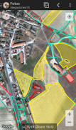
ऑनलाइन Google मानचित्र का विज़ुअलाइज़ेशन.
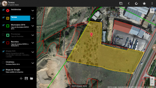
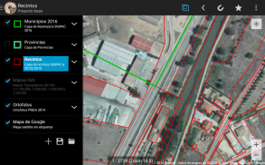
स्पैटियालाइट डेटाबेस में वेक्टरियल कार्टोग्राफी का उपयोग।
रैस्टरलाइट डेटाबेस से रैस्टर इमेजरी समर्थन।
ऑनलाइन WMS सेवाओं की खपत।
डिवाइस पर नई परतों का निर्माण और कॉन्फ़िगरेशन।
SQL प्रश्नों के आधार पर फ़िल्टरिंग, सहजीवन, लेबलिंग, खोज और पहचान प्रपत्र।
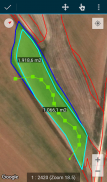
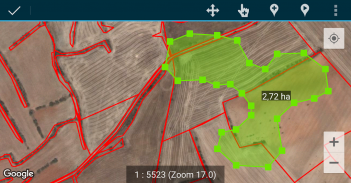
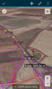
विशेषताओं का संपादन और ज्यामिति का मैन्युअल चित्रण।
जीपीएस-आधारित रेखांकन और ज्यामिति का संपादन।
उन्नत ज्यामिति संपादन उपकरण.
डेटा बचत सुविधाएँ, जिसमें भू-संदर्भित डेटा और चित्रों को संस्थाओं से जोड़ना शामिल है।
अतिरिक्त उपकरण जैसे SIGPAC खोज, माप उपकरण, नेविगेशन सहायता, बुकमार्क प्रबंधन।
एकाधिक प्रारूपों में आयात और निर्यात कार्यक्षमताएँ।
प्रायोगिक सुविधा के रूप में टीओसी प्रबंधन और एसएचपी फ़ाइल समर्थन।
परत संचालन नियंत्रण.
स्थान ट्रैकिंग के आधार पर सुविधाएँ बनाने के लिए कार्टोड्र्यूड पृष्ठभूमि स्थान सेवाओं का उपयोग करता है। उपयोगकर्ता स्थान का उपयोग केवल ज्यामिति शीर्ष या मानचित्र स्थिति बनाने के लिए किया जाता है, जिसमें डेटा स्थानीय रूप से संग्रहीत होता है और डिवाइस के बाहर नहीं भेजा जाता है। प्रोजेक्ट फ़ोल्डर हटाने से डेटा आसानी से हटाया जा सकता है।
सुविधाओं की पूरी सूची, डाउनलोड करने योग्य उदाहरण और आरंभिक मार्गदर्शिकाओं के लिए, www.cartodruid.es पर जाएँ।
CartoDruid - GIS offline tool - Version 0.62.9
(06-03-2025)CartoDruid - GIS offline tool - एपीके जानकारी
एपीके संस्करण: 0.62.9पैकेज: es.jcyl.ita.crtdrdLatest Version of CartoDruid - GIS offline tool
अन्य संस्करण


 4.34
4.34


Apps in the same category


You may also like...


